



















The development of ICEYE’s services for the military market, mentioned at the outset, is of course linked on the one hand to rising international tensions, particularly Russia’s invasion of Ukraine in February 2022, and on the other to the satellite cost revolution that has taken place in recent years. In essence, this comes down to the miniaturization and series production of satellites, which has led to a reduction in their unit cost. Their significantly lower mass compared with earlier designs has also clearly reduced the cost of placing them into orbit. At the same time, the cost per kilogram of payload launched into orbit has also fallen, further amplifying this effect.
As a result, these factors have significantly increased the availability of satellite systems for many customers that, for financial reasons, previously could not consider such a solution. Owning satellites has ceased to be a luxury reserved for the richest and most powerful states and has begun to become a tool used by medium-sized and even small countries.
 SAR satellites make it possible to observe the Earth’s surface regardless of weather conditions or time of day, making them an indispensable reconnaissance asset / Photos: ICEYE
More and More SAR Satellites
In the category of SAR radar satellites, the revolution mentioned above has taken place over the past decade, although it has intensified in the last few years. Without any exaggeration, it can be said that ICEYE has been the leader of this change. At the beginning of the current decade, SAR satellites could still almost be counted individually. Their known number slightly exceeded 20, of which four were already ICEYE designs, while a fifth had been developed in cooperation between ICEYE and York Space Systems. The largest national constellations at the time, operated by Italy and Germany, consisted of five satellites each, while six other countries (Argentina, Spain, Israel, Canada, Russia, and South Africa) had only one such system in orbit each. One more satellite belonged to the private US. company Capella Space. Even taking into account the fact that these figures do not include classified military satellites also equipped with synthetic aperture radar, they still show how few such systems existed only a few years ago.
Over the next two years, ICEYE tripled the number of its satellites, sending a further eight units of its own design into space, as well as one built in cooperation with R2 Space. The success of its own constellation attracted the attention of its first customers. In 2020, Brazil ordered a complete satellite system with a ground component and two satellites. Another customer followed on May 17, 2023, when the United Arab Emirates also ordered a complete system, including two ready-made satellites and five additional units to be assembled and tested locally. For this purpose, a joint venture was established in Abu Dhabi between ICEYE and the local company Space42, which is implementing the UAE space program aimed at creating national capabilities in satellite remote sensing and Earth observation.
 Infrequent observation of sites where major changes occur over time, such as ports or airfields, increases the risk of failing to detect the movement of forces stationed there in time
Customers from the EU and NATO
These first successes were only the beginning of a wave of orders that followed in the subsequent years. The effective use of data from ICEYE satellites by the Ukrainian military provided convincing evidence that funds spent on systems of this type are a very sound investment. This eventually also prompted member states of the European Union and the North Atlantic Alliance to make use of products from their own European company.
In September 2024, the signing of an agreement was announced with the Ministry of Digital Governance of Greece and the Hellenic Space Center for the purchase of two satellites under Axis 1.2 of the national program for building small remote-sensing satellites. In addition to the delivery of ready-made spacecraft, the contract also provided for the sale of additional data obtained using ICEYE’s corporate constellation.
The Netherlands came next, signing an agreement in February 2025 for the delivery to the Royal Netherlands Air Force of four Generation 3.5 satellites, together with a local ground system and a mobile segment with an AI-based autonomous imagery analysis center. As in the case of Greece, the agreement also provides for the purchase of satellite data from ICEYE.
Three months later, on May 14, 2025, Poland joined this group, ordering a complete system under the MikroSAR program, including three satellites and an option to purchase three more within the following 12 months. The next country to select an ICEYE product was Portugal. On June 12, the first order was placed for one satellite for the Portuguese Air Force. The agreement was concluded with CTI Aeroespacial, which is running the Spanish-Portuguese Atlantic Constellation program, intended both for environmental monitoring and military reconnaissance. This order was followed by another, for a second satellite, announced on December 2, 2025. This time, the customer was directly the Portuguese Air Force, Força Aérea Portuguesa. In September 2025, Finland also joined the group of ICEYE customers, acquiring a system with three satellites.
The largest order so far came from Germany. On May 8, 2025, ICEYE signed an agreement to establish, in cooperation with Rheinmetall, a company producing ICEYE satellites as part of the Rheinmetall Space Cluster. On November 7, information was released that the formation of the joint venture, named Rheinmetall ICEYE Space Solutions GmbH, had been completed. On December 18, it was announced that an order worth 1.7 billion EUR had been received from the Federal Office of Bundeswehr Equipment, Information Technology and In-Service Support (BAAINBw, Bundesamt für Ausrüstung, Informationstechnik und Nutzung der Bundeswehr). The order covered the provision of reconnaissance data to the German armed forces using their own independent constellation. Under this contract, as many as 40 ICEYE satellites are to be built to meet the Bundeswehr’s requirements. Production of the first units at the German facility in Neuss is scheduled to begin in the third quarter of 2026.
To sum up orders from NATO countries, the latest one should be added: from January this year, when a contract was signed with the Swedish Defence Materiel Administration (FMV, Försvarets materielverk). In this case, no details were provided regarding the number of satellites or the value of the agreement.
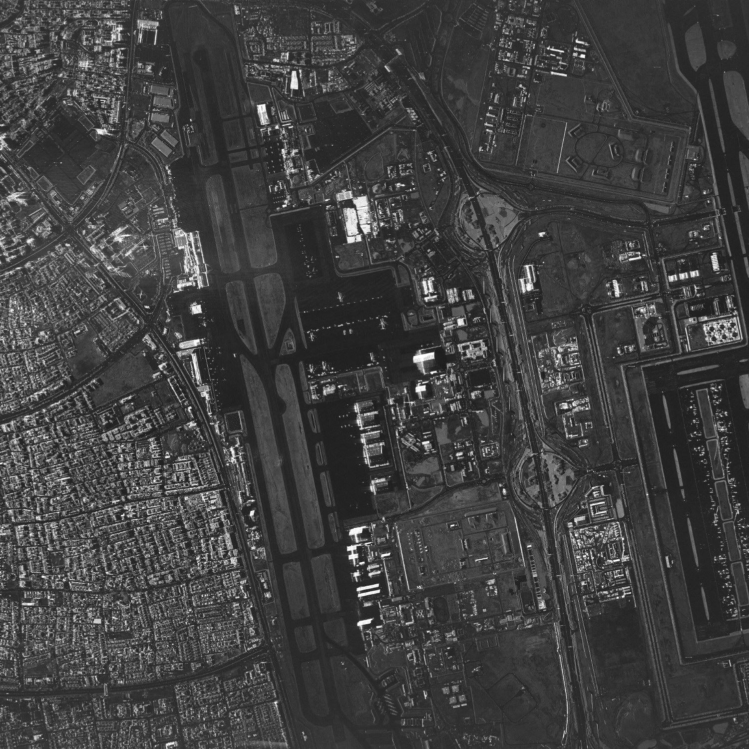 Increasing the frequency of observation of the same object on the Earth’s surface requires a larger number of satellites. To obtain another image every 20–30 minutes, a constellation of several dozen to 100 satellites is needed
A Joint NATO Constellation?
As can be seen from the above overview, European NATO countries have so far ordered more than 55 satellites from ICEYE. The rapid fulfillment of orders means that at least 11 of the ordered spacecraft are already in orbit: four Polish satellites of the POLSARIS constellation, including three from the core order and one through the exercise of an option; two Portuguese satellites; two Greek satellites; two Finnish satellites; and one Dutch satellite. The company’s production capacity last year was 25 satellites, while this year it plans to reach 50 units, which should enable the rapid fulfillment of signed contracts.
The number of orders from NATO countries is undoubtedly impressive. However, apart from the planned German constellation, the others consist of only a few satellites each and are unlikely to grow significantly. This limits the operational capabilities of each such grouping individually. If, however, all satellites available to Alliance countries were treated as a single constellation, they could make it possible to image the same area at intervals of around 30 minutes, and, with further numerical growth, even reduce this time to 20 minutes. This potentially offers entirely new capabilities for continuous tracking of troop movements, regardless of weather conditions or time of day. In this way, satellite data, currently used at the strategic or operational reconnaissance level, could easily become a source of intelligence at the tactical level.
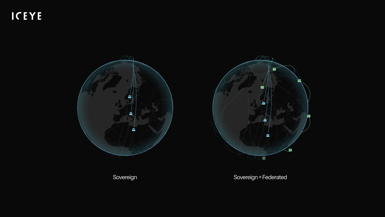 ICEYE’s latest idea for increasing the effectiveness of national constellations is to combine the efforts of allies in a federation
Increasing Capabilities
Hence ICEYE’s new idea: to enable the use of individual countries’ unused capacity for the benefit of other allies. The proposal involves creating an association of users of this type of satellite reconnaissance asset, referred to in corporate terminology as a federation, which would enable the shared use of available resources.
The concept comes down to creating, within a framework of cooperation, the ability to task satellites belonging to an allied country from the system of another state. If an image of a given area of interest could be obtained more quickly using a satellite owned by someone else, a request would be sent to the operator asking whether its constellation could be used. If, at that moment, the satellite had no other priority tasks, it could carry out the allied request. Since different countries have different priority areas of interest, during passes over certain regions their satellites may remain unused or not fully used, while other allies may be interested in obtaining additional reconnaissance information from those areas.
For example, it may be assumed that Russian military facilities on the Kola Peninsula will be of particular interest to Finland or Sweden, but to a lesser extent to Poland, the Netherlands, or Germany, and least of all to Greece or Portugal. In such a case, satellites of the latter countries passing over that area would probably not be fully used and could be tasked with taking images on behalf of Finland, for instance. Similarly, a Finnish or Swedish satellite over the Mediterranean would probably not receive many tasking requests from its own armed forces and could successfully operate on behalf of allies on NATO’s southern flank.
Overall, then, the idea is to optimize the use of already available resources. For an individual user, this would increase its own capabilities by making it possible to use an ally’s assets where and when its own are not available, as well as by increasing the frequency of imagery collection over a priority location.
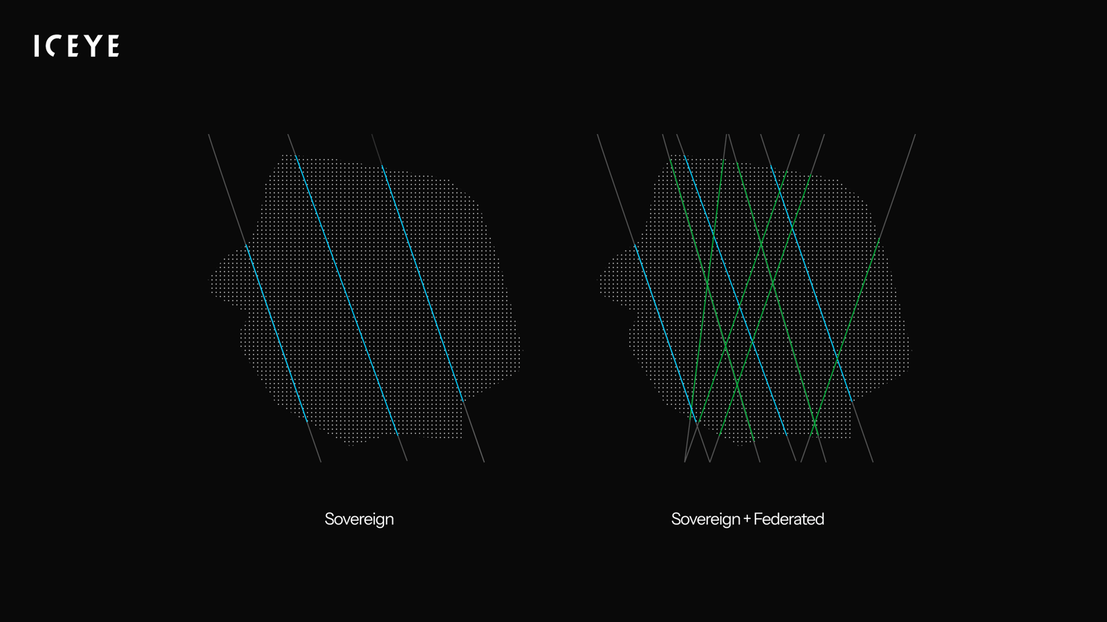 The concept comes down to creating, within a framework of cooperation, the ability to task satellites belonging to an allied country from the system of another state, thereby increasing the availability of reconnaissance information
The National Operator Will Decide
From the software perspective, the concept is based on ICEYE’s currently used mission planning system. Internal testing is now under way, and the company says it will soon be ready to verify the proposed solution in cooperation with other users. Deployment of an initial version could be possible within a few months.
ICEYE intends to base the operation of such a system on peer-to-peer communication between interested parties. Under this form of cooperation, each participating state would have access to the orbital parameters of partner satellites, allowing it to know which of them would be able to image a given area of interest the fastest. At the same time, each state would retain full control over the operation of its own fleet and the use of its resources.
By making satellite-position information available to partners within the system, it would be possible to coordinate activities and optimize the use of resources within a given area of interest. However, the decision whether to make its resources available to an ally, or to reject the request because of its own priorities, would always rest with the national operator. This system architecture would allow for minimal external interference in national systems, while only two parties would know that a given asset was being used: the requester and the provider.
The existing satellite-to-ground data transfer system already allows for multiple data-flow variants. Technically, transmission from a satellite can be received either by the satellite operator’s national ground component or directly through the ground segment of the partner that requested the task. Potentially, commercial infrastructure could even be used for this purpose.
 Last year, ICEYE expanded its offering with the containerized ISR Cell mobile satellite operations center. It enables ready-to-use information to be delivered to commanders within a dozen or so minutes
Higher-Level Participant
The system architecture adopted, based on peer-to-peer communication, also allows a higher-level participant, for example at NATO command level, to join the system on the same terms. This could further optimize the use of reconnaissance assets across the Alliance as a whole. ICEYE already provides imagery to the Situation Center, or SITCEN, at NATO Headquarters, while on June 24, 2025, Allied Command Operations, or ACO, one of NATO’s two strategic commands, became another recipient of its data.
This took place as part of the Alliance Persistent Surveillance from Space, or APSS, initiative. Its goal is to increase the sharing of satellite intelligence across the Alliance in order to provide the most comprehensive data possible for political and military decision-making. It seems that the technical capability introduced under the federation to use the entire fleet of allied countries’ SAR radar satellites would fit well with this concept. The adoption of specific organizational and legal solutions depends solely on the will of the system’s participants, while the software being prepared will provide the technical basis for possible cooperation.
Moreover, from a technical perspective, there is nothing preventing ICEYE’s commercial assets from also being included in the federation. This is solely a matter of an appropriate agreement. Considering that, in addition to the NATO institutions mentioned above, some countries already have agreements for the delivery of additional data from ICEYE’s corporate constellation, such a combination could be expected to allow for an even higher frequency of imaging of critical areas.
In a sense, a step in this direction is the Tactical Access subscription service introduced in October last year. It is intended for regular customers who expect short tasking timelines, high planning flexibility, and rapid data delivery. It enables subscribers to reserve imaging capacity, guaranteeing immediate availability when needed. Under Tactical Access, it is also possible to purchase a dedicated ground station consisting of an antenna and an ICEYE Edge image-processing unit. This enables direct reception of satellite data and the generation of ready-to-use imagery within minutes of receiving raw data, compared with several hours when using ICEYE’s infrastructure as an intermediary. Functionally, this solution is already very close to what is being proposed under the federation.
It should also be added that the first steps toward allied cooperation among ICEYE satellite users have already been taken. In December 2025, the Finnish Ministry of Defence signed a Letter of Intent with Poland and the Netherlands on cooperation in the use of newly acquired SAR satellites. This partnership is expected to lay the foundations for cooperation between the countries and improve their monitoring and reconnaissance capabilities.
The company’s proposal is certainly interesting. Increasing the operational capabilities of existing constellations using only one’s own assets requires the purchase of additional satellites, and therefore additional costs. These will not always be justified, because in a period of reduced international tension, existing capabilities may prove excessive, while during a subsequent rise in tension it may not be possible to quickly increase the capacity of one’s satellite grouping. In this case, the shared use of allied assets is certainly a way to optimize both costs and reconnaissance capabilities. The remaining question is how this solution will be received by potential users.