


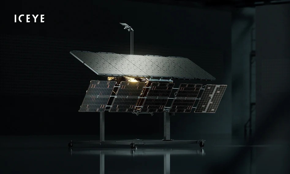
The Finland-registered company ICEYE was founded in 2014. Its founders were Polish national Rafał Modrzewski and Finn Pekka Laurila, who met at Aalto University, where Rafał Modrzewski was studying under the Erasmus program. They became involved in the then-emerging trend of building mini-satellites (weighing 100–180 kg) and micro-satellites (weighing 10–100 kg). The foundation of this concept was the creation of small devices that could be built quickly, cheaply, and launched into orbit in large numbers. At the time, the common practice was to construct complex satellites with high capabilities; however, this approach resulted in heavy, expensive, and therefore few in number. The new idea focused on building lightweight, specialized devices produced in larger quantities (and thus cost-effective), with less stringent performance requirements and shorter operational lifespans. Such satellites could be easily replaced in the event of failure, operated in prominent constellations, and frequently replaced with new units.
The ICEYE-X1 satellite was launched into orbit on January 12, 2018. Weighing only 66 kg, it served as a demonstrator intended to practically verify the adopted assumptions. It proved that constructing a miniature radar capable of successfully operating in Earth orbit, within the harsh environment of space, is entirely feasible
Civilian beginnings
The founders’ concept was to create a small satellite equipped with a Synthetic Aperture Radar (SAR). This would allow it to deliver images of the Earth’s surface without the limitations typical of satellites taking photographs in visible light, namely, being restricted to daytime and clear skies. Using microwave-band electromagnetic waves to capture images enables the observation of targets even in poor weather conditions and at night. Capabilities that were previously available only to a limited number of users, primarily government agencies, were intended to become much more widespread and accessible to a broader audience through their products.
Originally, ICEYE’s focus was on observing the ice cover of the Arctic Ocean, which has been steadily shrinking due to global warming. The company’s name originates from this idea, a combination of the words “ice” and “eye.” The business plan was therefore aimed at monitoring ice conditions along Russia’s Northern Sea Route, which is becoming increasingly accessible as the ice recedes. This route was drawing growing interest from companies looking to exploit Russian oil and gas deposits in the Arctic. ICEYE’s first client was Exxon Mobil, which planned to transport liquefied natural gas from the Yamal Peninsula, where the port of Sabetta was under construction at the time.
ICEYE-X2, which was launched into orbit on December 3, 2018, aboard a Falcon 9 rocket, was the prototype for the series-produced satellites defined as the second generation. It was a somewhat larger device, weighing 85 kg, and equipped with an ion engine allowing for orbital adjustments
The original business concept, however, was disrupted by the events of February–March 2014, Russia’s aggression against Ukraine, which resulted in the annexation of Crimea. The sanctions imposed on Russia, including those concerning cooperation with significant oil and gas companies, rendered the already signed contract, as well as hopes for that business direction, obsolete. This forced a change of strategy. ICEYE had to move away from the idea of narrow specialization and seek other clients. The company therefore decided to offer radar images of the Earth for various applications, including monitoring areas affected by natural disasters and infrastructure surveillance.
From Plans to Reality
The first ICEYE satellite, still a demonstrator intended to practically verify the adopted assumptions, was launched into orbit on January 12, 2018, aboard an Indian PSLV-XL rocket. The small device, weighing only 66 kg and designated ICEYE-X1, proved that constructing a miniature radar capable of successfully operating in Earth orbit within the harsh environment of space was entirely feasible. The company thus became the world’s first manufacturer and operator of radar microsatellites. This success spurred rapid growth, and by the end of 2018 the company had already announced plans to open branches in Poland and the United States.
 Just a week after the launch of ICEYE-X2, on December 11, 2018, the company presented the first image captured with its help. The image, covering an area of 25 x 20 km with a resolution of 3 x 3 meters, showed a part of Spain
After a five-month testing period, on June 29 ICEYE announced the successful verification of all assumptions and the end of operations of its first spacecraft. During this time, ICEYE-X1 captured more than 600 images. The experimental radar did not yet have impressive parameters, providing images with a ground resolution of 10×10 meters, suitable only for general Earth surface observation. However, this was enough for Norway’s Kongsberg Satellite Services (KSAT) to sign a contract on March 7, 2018, for the purchase of images taken by the satellite. It should be noted here that KSAT operates a network of ground stations used to communicate with satellites in polar orbits, a service that ICEYE also uses.
The successful experience with the first spacecraft paved the way for launching the target satellite, which served as a template for the later series. The prototype ICEYE-X2 was launched into orbit on December 3, 2018, aboard a Falcon 9 rocket. It was a somewhat larger device, weighing 85 kg and equipped with an ion engine for orbital adjustments. In 2019, ICEYE placed three more satellites into orbit: on May 5, ICEYE-X3, another prototype built in cooperation with the American company York Space Systems (later named Harbinger), and on July 5, two series-production units of its own design – ICEYE-X4 and ICEYE-X5. A little over a year later, on September 28, 2020, the constellation was expanded with another pair: ICEYE-X6 and ICEYE-X7. This increased the number of available second-generation satellites to five.
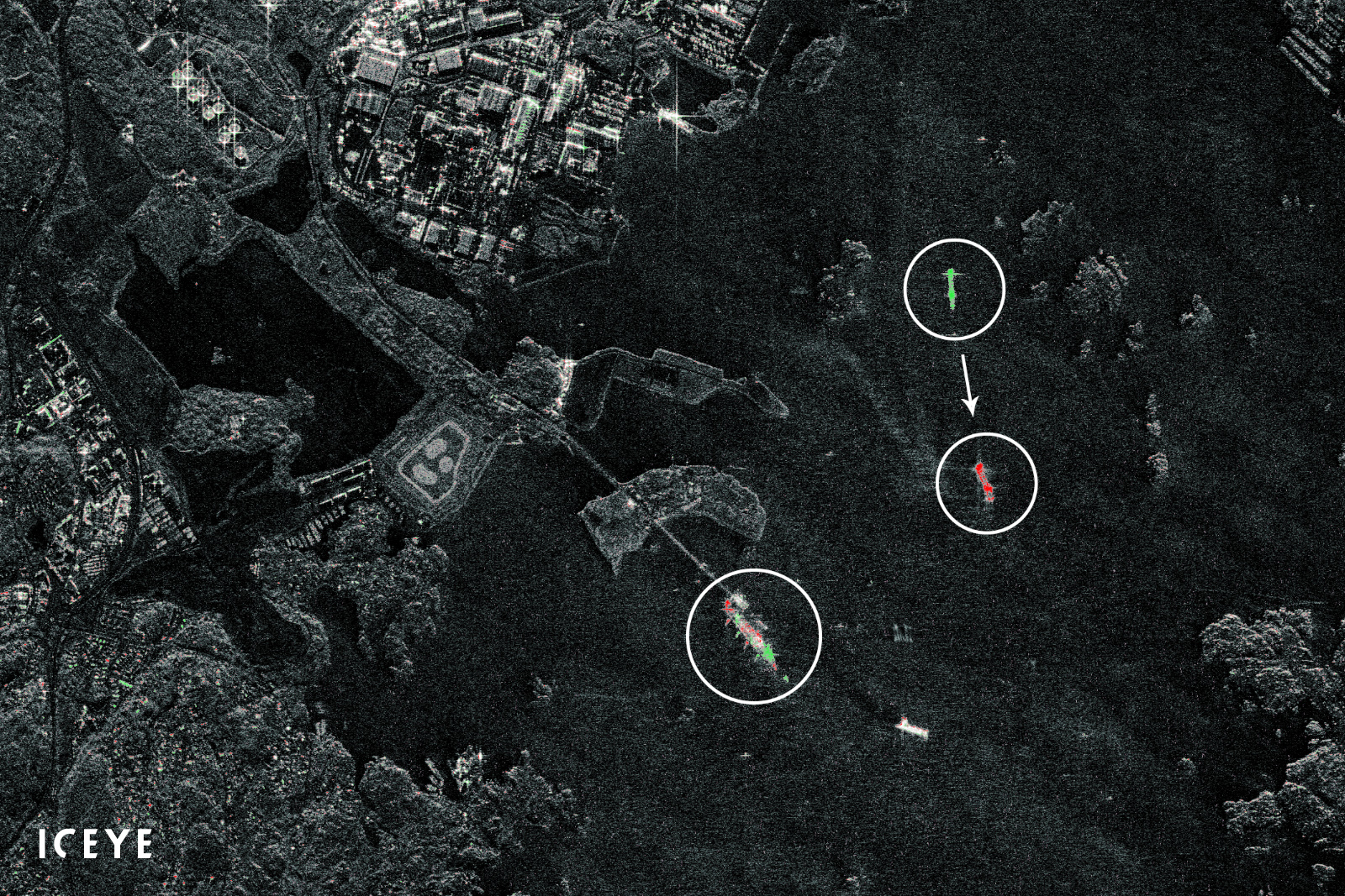
The capabilities offered by operating a large satellite constellation, and thus enabling frequent revisits of the same location, are illustrated by an image of the port of Gothenburg from July 2019. Two images taken just a few minutes apart by the satellites ICEYE-X4 and ICEYE-X5 were overlaid, allowing the movement of a vessel leaving the port to be recorded. Elements visible only in the earlier image were marked in green, while those visible only in the later image were marked in red
What does the ICEYE radar see?
One of the characteristics of small SAR satellites is that, due to their size, they employ a different operating mode than many traditional designs. Large radar satellites could operate continuously, illuminating the Earth’s surface throughout their orbit. Small satellites, however, due to their limited available energy, do not emit continuous light; instead, they illuminate only selected areas, capturing radar images of them. Battery capacity thus becomes one of the factors determining how many images can be taken between recharges using photovoltaic panels.
The first operational radar model used in ICEYE’s second-generation satellites (starting with ICEYE-X2) was an electronically steered X-band radar operating at a carrier frequency of 9.65 GHz (wavelength 3.1 cm). It was equipped with an active phased-array antenna measuring 3.2 x 0.4 m, with a peak power of 3.2 kW. The first images it produced had a ground resolution of 3 x 3 m. The operating mode used for these images, called Stripmap, involved continuously illuminating a 30 km wide and 50 km long strip of terrain.
Since, in the case of synthetic aperture radar, azimuth resolution depends only on the length of the synthesized aperture, this parameter can be relatively easily improved. A new operating mode, called Spotlight, was quickly developed and its introduction announced at the beginning of August 2019. It involved illuminating a selected area measuring 5 x 5 km for 10 seconds. This allowed the slant resolution to be improved to 0.5 x 0.5 m, resulting in a ground resolution of at least 1 x 1 m.
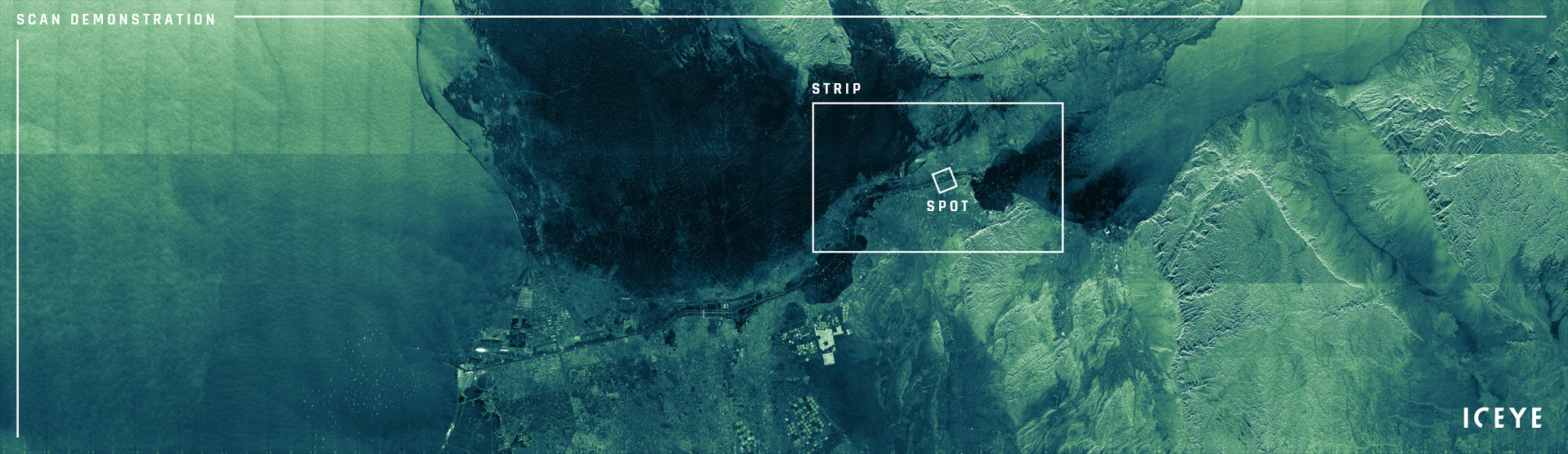 Comparison of the areas covered in Scan, Strip, and Spot modes, using an image of the Suez Canal as an example. In Scan mode, with the resolution reduced to about 15 x 15 m, it is possible to capture imagery of a strip 100 km wide and up to 840 km long (in this case 400 km), which is sufficient for monitoring large vessels
Ongoing work on introducing additional modes resulted in expanded device capabilities in March 2020. A new mode with a twice-as-long, 20-second illumination of the selected area was introduced. This allowed the azimuth resolution to be improved to 25 cm, and through processing the collected data into multiple frames rather than a single image, it became possible to create short animations. These made it possible to observe changes in the positions of moving objects during terrain monitoring.
Recognizing that customers might also find lower-resolution but wider-area images useful, a new Scan mode was developed and introduced in May 2021. In this mode, resolution was reduced to about 15 x 15 m, but it enabled imaging of large areas in strips 100 km wide. The standard image length was initially 100 km, later extended to 500 km, and eventually to 840 km. Such imagery is fully sufficient for monitoring medium and large vessels over vast areas ranging from 10,000 to 84,000 km².
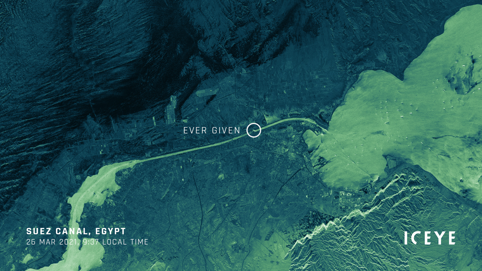
The presented imagery was taken in 2021, at the time when the container ship Ever Given blocked the Suez Canal. The Strip mode shown above is sufficient to pinpoint the location of the incident
Third and fourth generation
Improvements to the radar itself came with the development of the third-generation satellite, the prototype of which was launched into orbit on June 12, 2023. While the antenna dimensions and peak power remained unchanged, the beam angle range was expanded from 15 ° to 35 ° to 5 ° to 45 °, and the radar bandwidth was doubled to 600 MHz. This enhanced the range resolution from 0.5 m to 0.25 m, resulting in an improvement in ground resolution from 1 m to 0.5 m. These values provided ground target recognition capabilities comparable to older optical systems. The new generation of satellites also introduced a new data transfer link, increasing throughput from 140 to 500 Mbit/s. All these changes also resulted in an increase in mass, from 92 to 110 kg.
New imaging modes were also progressively developed. In May 2023, a new Dwell mode was introduced, similar to Spotlight but with an extended exposure time of up to 25 seconds. The longer illumination, and thus an azimuth resolution as fine as 5 cm, was used to enhance the quality of the final image, significantly reducing speckle noise, spot-like artifacts that appear at very high resolution. Newly developed imaging modes are also being implemented on older satellites through software updates. An exception is the new high-resolution modes, Spot Fine and Dwell Fine, which are available only on third-generation satellites equipped with the expanded radar bandwidth.
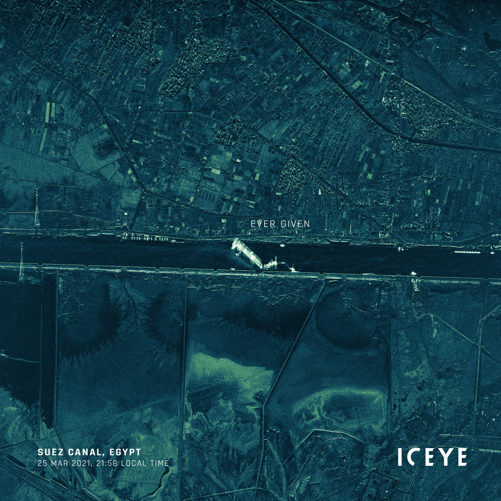
At the time, the most precise Spot mode made it possible to observe the details of the operation to refloat the ship from the shoal
The next satellite, designated as Generation 3.5 and launched on March 5, 2024, was equipped with a radar whose bandwidth was once again doubled, to 1200 MHz. This is the maximum value permitted for commercial satellites by the International Telecommunication Union. It enabled ground resolution to be increased to 25 cm, comparable to optical satellites. Along with the technical improvements, it also received an enhanced imaging mode, Dwell Precise.
After just one year, on March 15, 2025, the prototype of the newest fourth-generation satellite was launched into orbit, equipped with a radar featuring a twice-as-large antenna and doubled peak power. This allows the maximum imaged swath width to be increased to 400 km, with each new image containing 30% more information density. Further upgrades include an improved orbit control system and increased memory capacity, allowing for a greater number of images to be captured during a single pass over a given area.
The third generation of ICEYE satellites, whose prototype was launched into orbit on June 12, 2023, was equipped with a radar featuring an expanded beam angle range from 15–35º to 5–45º and a doubled bandwidth from 300 to 600 MHz. This improved range resolution from 0.5 m to 0.25 m, which translated into an increase in ground resolution from 1 m to 0.5 m. The new generation of satellites also introduced a new data transfer link with throughput increased from 140 to 500 Mbit/s. All these changes also resulted in an increase in mass from 92 to 110 kilograms
Almost all ICEYE satellites are placed in low Earth orbit at altitudes between 500 and 600 km. This is a polar sun-synchronous orbit with an average inclination to the equatorial plane of 97.5–97.8º. An exception are two satellites launched on December 21, 2024 (ICEYE-X47 and ICEYE-X49), which are in an orbit inclined at 45º. While this increases the frequency of imaging at mid-latitudes, it makes the orbit of limited use in regions such as Poland.
First Military Users
The undeniable success achieved by ICEYE, which in 2019 had created a still modest constellation of three second-generation satellites, attracted the attention of its first military customer: the Força Aérea Brasileira (Brazilian Air Force). In 2020, a contract was signed with FAB for ICEYE to build two radar satellites under the Lessonia-1 program. The program envisioned the acquisition of a low-orbit SAR satellite constellation for the needs of the armed forces, the Amazon Protection System Management and Operations Center (CENSIPAM – Centro Gestor e Operacional do Sistema de Proteção da Amazônia), and civilian government agencies. The satellites, built in 2021, were successfully placed into orbit on May 25, 2022, receiving the Brazilian names Carcará I and Carcará II. After more than two years of operation, they were replaced by another pair of ICEYE satellites: ICEYE-X39 and ICEYE-X43, which were launched on August 16, 2024. Meanwhile, the original two were deorbited in March of this year.

Image of the Russian naval base in Severomorsk taken in Dwell Precise mode
The Brazilians were also the first customers to purchase a complete system from ICEYE. They operate their own ground infrastructure, which allows them to run the acquired satellites entirely autonomously.
At the heart of the system is the Space Operations Center (COPE – Centro de Operações Espaciais) in Brasília, the capital, which has been operating since 2020. On March 13, 2025, COPE fully assumed control over the Lessonia-1 system and the radar imagery it provided. The satellite images are used, among other things, for border control, monitoring fires and natural disasters, observing the exclusive economic zone, combating drug trafficking and illegal mining, updating cartographic data, and assessing river navigability.
Another impetus for strengthening ICEYE’s military business direction came with the growing tensions on Poland’s eastern border. In 2021, during the massing of Russian troops around Ukraine, the U.S. Department of Defense approached ICEYE to ask about access to imagery. The answer was positive, and this can be considered a turning point, marking a shift in ICEYE’s services toward defense applications.
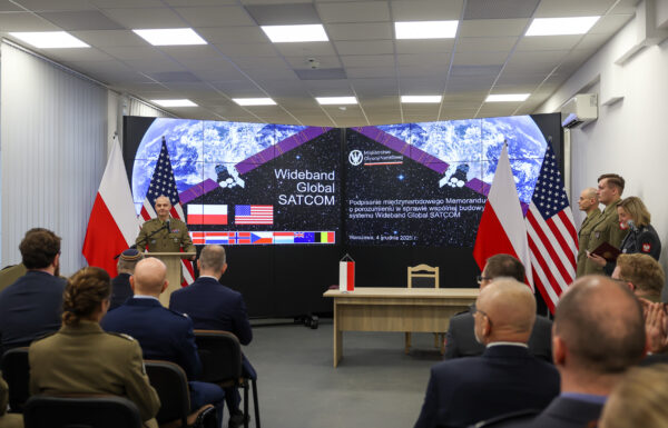
Shortly thereafter, on January 20, 2022, ICEYE US was selected as one of five companies admitted into a program assessing commercial radar imagery providers for U.S. satellite reconnaissance needs. The contract signed at that time with the National Reconnaissance Office (NRO) placed ICEYE among an elite group of companies cooperating with U.S. intelligence. Alongside ICEYE, the entities admitted to the first phase of the program included three U.S.-based companies: Capella Space, PredaSAR, and Umbra Space, as well as the American branch of the European industrial giant, Airbus US.
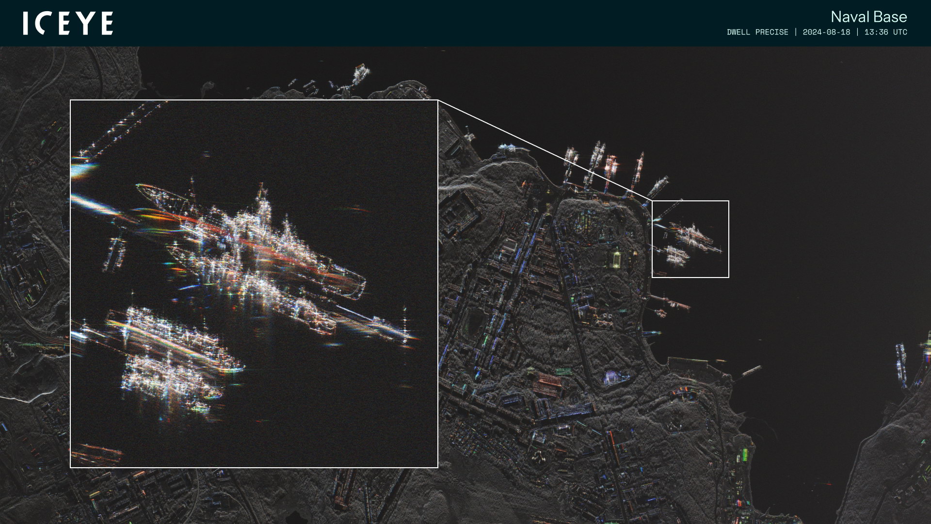
In the enlarged section shown, specialists can easily identify the Pyotr Velikiy nuclear-powered missile cruiser of Project 11442 (Kirov class) and the Marshal Ustinov cruiser of Project 1164 (Slava class), which makes it possible to monitor their activity in all weather conditions, at any time of day or night
Development of constellation
At that time, the company had already completed 14 successful launches. In 2021 alone, a total of seven new satellites were sent into orbit: three on January 24 (including the ICEYE-X10 satellite, built in cooperation with another American company, R2Space, and later renamed XR-1), and another four on June 30. ICEYE thus had 11 of its own satellites in orbit. The number of available spacecraft provided significant capabilities in terms of revisit frequency over selected areas, placing ICEYE in a leading position in this type of service.
The start of Russia’s invasion of Ukraine on February 24, 2022, only increased the demand for reconnaissance data. On August 18, 2022, an agreement was signed with the Serhiy Prytula Charity Foundation, granting exclusive use of one ICEYE satellite already in orbit, as well as access to imagery from the entire constellation, enabling frequent monitoring of critical areas.
The next customer to decide on purchasing a complete satellite system was the United Arab Emirates. The contract was signed on May 17, 2023, with Bayanat and Yahsat (which merged on October 1, 2024, to form Space42), jointly implementing a comprehensive space program aimed at developing national capabilities in satellite remote sensing and Earth observation. Space42’s plans include creating a constellation of seven radar satellites. Of these, two built by ICEYE have already been launched: Foresight-1 on August 16, 2024, and Foresight-2 on January 14, 2025, with subsequent satellites planned for development in the UAE. A joint venture established in Abu Dhabi by ICEYE and Space42 will handle assembly, integration, and testing of the new satellites. The capital will also host a satellite operations center.
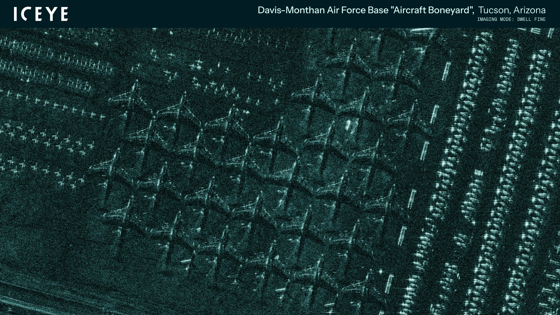
The Dwell Fine mode makes it possible to observe individual objects the size of an aircraft. Unlike imagery taken in the visible spectrum, radar imaging does not allow for easy identification of a specific type, but it is sufficient to register the presence of individual units and determine their size. The image shows, among others, C-5 Galaxy transport aircraft stored at Davis-Monthan Air Base in Arizona
A Year of Achievements
The past year can undoubtedly be described as a string of successes for ICEYE. Years of development and the creation of the world’s largest radar satellite constellation have enabled the company to achieve a leading market position and secure new clients. On September 8, 2024, ICEYE announced the signing of a contract with the Greek Ministry of Digital Governance and the Hellenic Space Agency (ELDO – Ellinikós Diastimikós Organismós) for the implementation of Axis 1.2 under the national small remote sensing satellite program. Axis 1.2 covers the capability to acquire radar imagery using SAR satellites. The contract with ICEYE provides for the delivery of two ready-to-launch satellites along with their deployment into orbit, as well as the sale of data collected through ICEYE’s constellation.
Two months later, on December 5, 2024, the U.S. National Reconnaissance Office announced that ICEYE had been awarded a two-year contract to provide satellite imagery. This is an extension of the 2022 agreement; however, only three of the five companies that participated in earlier phases qualified for this stage. Alongside ICEYE US, the other two U.S.-based companies are Capella Space and Umbra Space.
The Russian invasion of Ukraine, now in its fourth year with no end in sight, has also spurred greater interest in radar satellite reconnaissance from NATO command. On March 28, ICEYE announced it would begin providing imagery to the Situation Center (SITCEN) at NATO Headquarters. On June 24, as part of the Alliance Persistent Surveillance from Space (APSS) initiative, its data was also made available to Allied Command Operations (ACO), one of NATO’s two strategic commands. The goal of the APSS program is to enhance the sharing of satellite intelligence across the alliance, providing the most complete possible reconnaissance picture necessary for informed political and military decision-making.
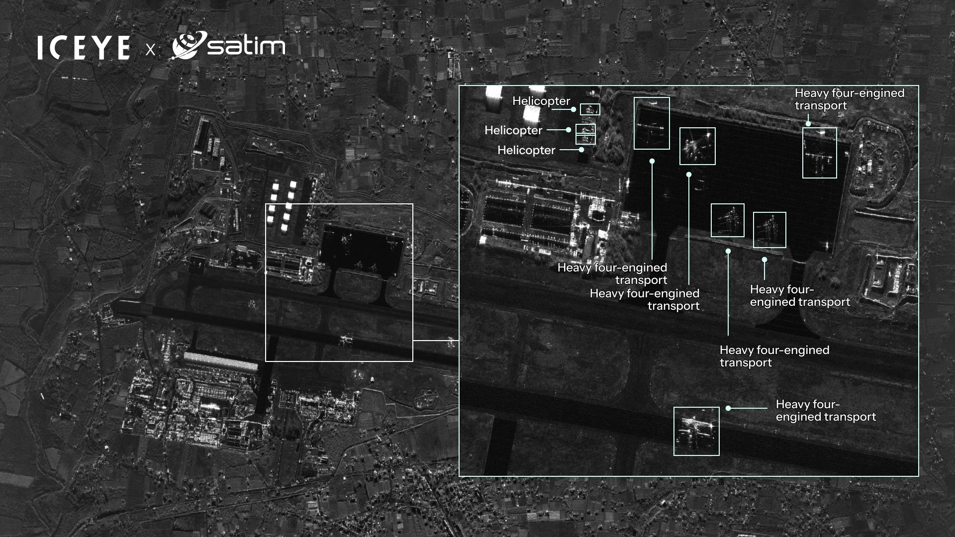
Rapid acquisition of information and interpretation of received imagery is of key importance during combat operations. In this area, ICEYE has established cooperation with leading companies in the field, including SATIM, which specializes in automatic target identification systems
Individual NATO member states have also recognized the reconnaissance capabilities of this type of satellite. This year alone, four countries have already signed agreements with ICEYE.
The first was the Royal Netherlands Air Force (Koninklijke Luchtmacht – KLu), which signed a contract in February. The Dutch decided to order four Generation 3.5 satellites with a resolution of 25 cm, as well as a local ground segment with an antenna and a mobile ground segment equipped with an autonomous AI-based imagery analysis center. The first satellite was to be launched within four months of the contract signing, which indeed took place on June 23 of this year. The agreement also includes access to satellite data from ICEYE’s constellation, significantly enhancing the ability to obtain imagery when required rapidly.
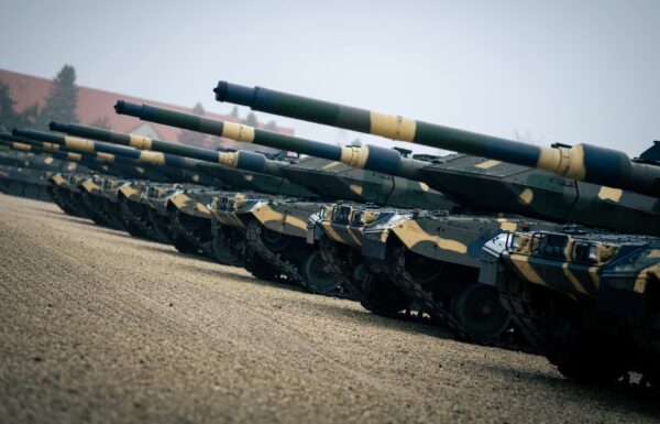
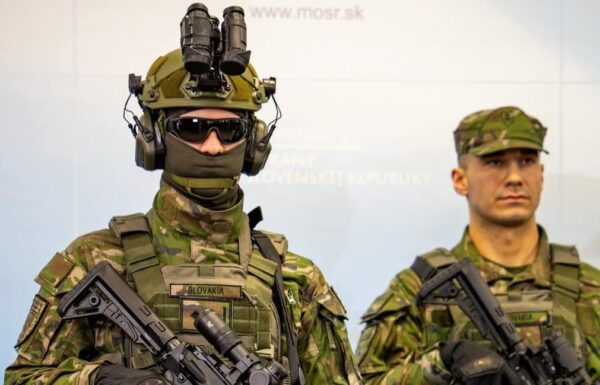
The next customer was Poland, which on May 14 signed a contract to supply the Polish Armed Forces with three satellites under the MikroSAR program. The launch of the first satellite from this constellation, also Poland’s first military satellite, is scheduled for later this year. As in Brazil’s case, a complete system was purchased, consisting of both orbital and ground components. The latter will be co-developed by Wojskowe Zakłady Łączności No. 1, which is building the mobile ground segment along with an antenna for satellite communication and data reception. The contract, valued at approximately PLN 860 million gross, also includes an option to purchase an additional three satellites and further ground segment components within 12 months.
The next order came from Portugal, on June 13, a contract was signed to deliver one satellite, along with a ground segment and communication antenna, for the Força Aérea Portuguesa. These will be provided to CTI Aeroespacial, which is leading the Spanish-Portuguese Atlantic Constellation program. This initiative envisions the creation of a joint constellation of 26 small satellites: 14 optical and 12 radar, serving both environmental monitoring and military reconnaissance needs. Since a single satellite represents only a small part of this plan, it is no surprise that further discussions are underway regarding the possible purchase of additional satellites from ICEYE, which would be assembled in Portugal.
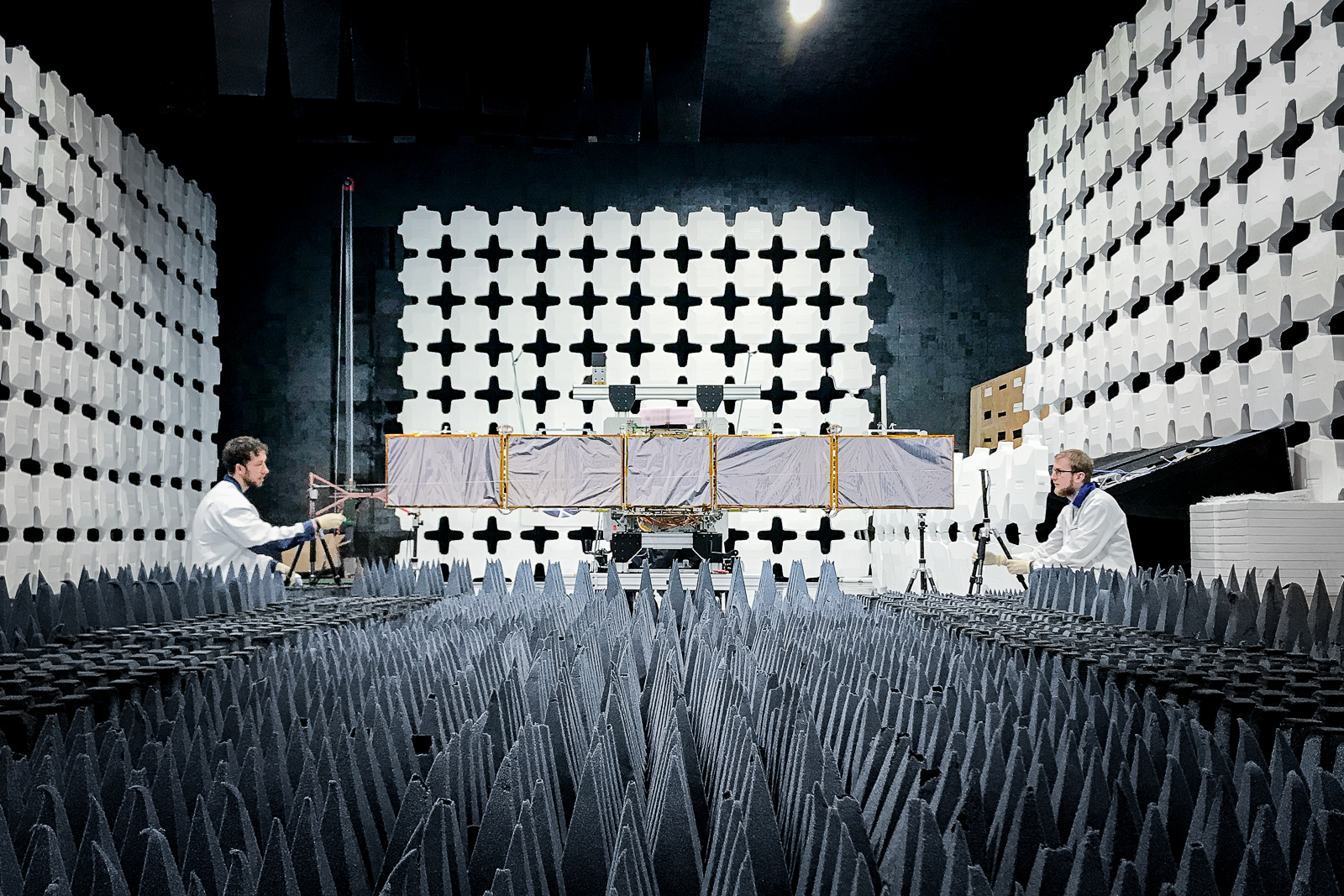
ICEYE satellites are currently being built in two locations: Finland and the United States. Some components are designed and manufactured by ICEYE Poland, which hosts the company’s research and development laboratory. ICEYE also plans to establish a joint venture with Rheinmetall, which, starting in the second quarter of 2026, will produce SAR satellites as part of the German Rheinmetall Space Cluster. The photo shows a satellite being tested in an anechoic chamber.
The most recent agreement concluded by ICEYE to date is a letter of intent with the Finnish Ministry of Defence. It outlines a schedule and preliminary delivery plan, as well as a discussion of the technical solutions needed to establish Finland’s own autonomous satellite reconnaissance capabilities.
ICEYE’s Potential
International Competition
There are currently three companies on the market operating their own small SAR satellites and potentially competing with ICEYE. Two of them are American: Capella Space and Umbra Space. The former has placed 15 satellites into orbit since 2018 (with the sixteenth scheduled for launch on August 26 of this year), while the latter launched 10 spacecraft between 2021 and 2024. Notably, in both cases, a large portion of these have already been deorbited. Both companies currently operate constellations of five satellites each, all of which were launched between 2023 and 2025. Japanese iQPS has slightly better statistics, having placed 10 SAR satellites into orbit since 2019, of which seven remain operational, also launched between 2023 and 2025.
On March 15, 2025, the prototype of the newest fourth-generation satellite was placed into orbit, equipped with a radar featuring a twice-as-large antenna and doubled peak power. This allows the maximum imaged swath width to be increased to 400 km, with each new image containing 30% greater information density. Further improvements include an enhanced orbit control system and expanded memory capacity, enabling a larger number of images to be captured during a single pass over a given area
Companies do not disclose the reasons for their failures, so it is unclear what exactly causes such frequent, and often seemingly premature, deorbitations. Suspicion falls on the design of these satellites. All three companies’ spacecraft are equipped with large parabolic antennas. In low Earth orbit, even the residual atmosphere can generate drag, leading to faster orbital decay and, consequently, excessive propellant consumption. This problem is far less pronounced in ICEYE’s design, where a relatively small flat antenna does not create comparable drag. Supporting this assumption is the fact that ICEYE-X2, launched on December 3, 2018, remains operational and in a working orbit more than 550 km above Earth, despite being in service for more than six and a half years, which is two to three times its intended lifespan.
Experience has also shown that despite the rapid development of small satellites, no new companies offering SAR satellites have appeared on the market so far. Capella Space was founded in 2016, Umbra Space in 2015, and Japanese iQPS back in 2005. No other player has yet put its own SAR satellite into orbit, while PredaSAR has completely abandoned its ambitious plans to build a constellation of as many as 96 satellites. This does not mean that new entrants will not appear; however, the more experience companies already in orbit accumulate, the harder it will be for newcomers to break into the market. A serious threat to existing ventures could instead come from large corporations like SpaceX, which have extensive experience, capacity, and financial resources.
Paradoxically, current U.S. arms trade regulations are working against American manufacturers themselves. ITAR (International Traffic in Arms Regulations) rules limited the sale of satellites equipped with synthetic aperture radars to systems with a bandwidth of no more than 300 MHz, corresponding to a ground range resolution of about 1 m. The new proposal from October 2024 raised this limit only to 500 MHz, still short of half-meter resolution. This was criticized by Umbra Space, whose representative said that it would make it impossible for U.S. producers to compete in foreign markets, where they will be outmatched by ICEYE and other companies from Italy, France, Germany, or even China, whose radars can use the full 1200 MHz range permitted under international regulations.
Future Directions of Development
ICEYE currently has no fixed target for the size of its constellation. This will depend on market demand for such services. As demand continues to grow, the company plans to launch more than 20 new satellites into orbit annually in the coming years. One of the primary objectives of the constellation is to achieve extremely short revisit times over a specific location. To achieve the desired 20–30 minutes, approximately 100 satellites would be required in orbit. Reducing the revisit time further to 15–20 minutes, the practical limit of cost-effectiveness, would require a constellation of around 200 satellites worldwide.
The current production capacity stands at approximately 25 satellites per year, with the cost of a single unit estimated at around USD 25 million. Satellites are built in two locations: Finland and the United States. Some components are designed and manufactured by ICEYE Poland. Further development of the Polish subsidiary is planned, which already operates a research and development laboratory in Warsaw, as well as a Satellite Operations Center. The center oversees the company’s entire constellation, except for those satellites managed by a similar facility in Irvine, California. Both the establishment of a local operations center and the production of satellites in the U.S. stem from requirements for market presence and cooperation with American institutions. ICEYE also intends to establish a joint venture with Rheinmetall. Under the name Rheinmetall ICEYE Space Solutions, it is expected to begin producing SAR satellites in the second quarter of 2026 as part of the German Rheinmetall Space Cluster.
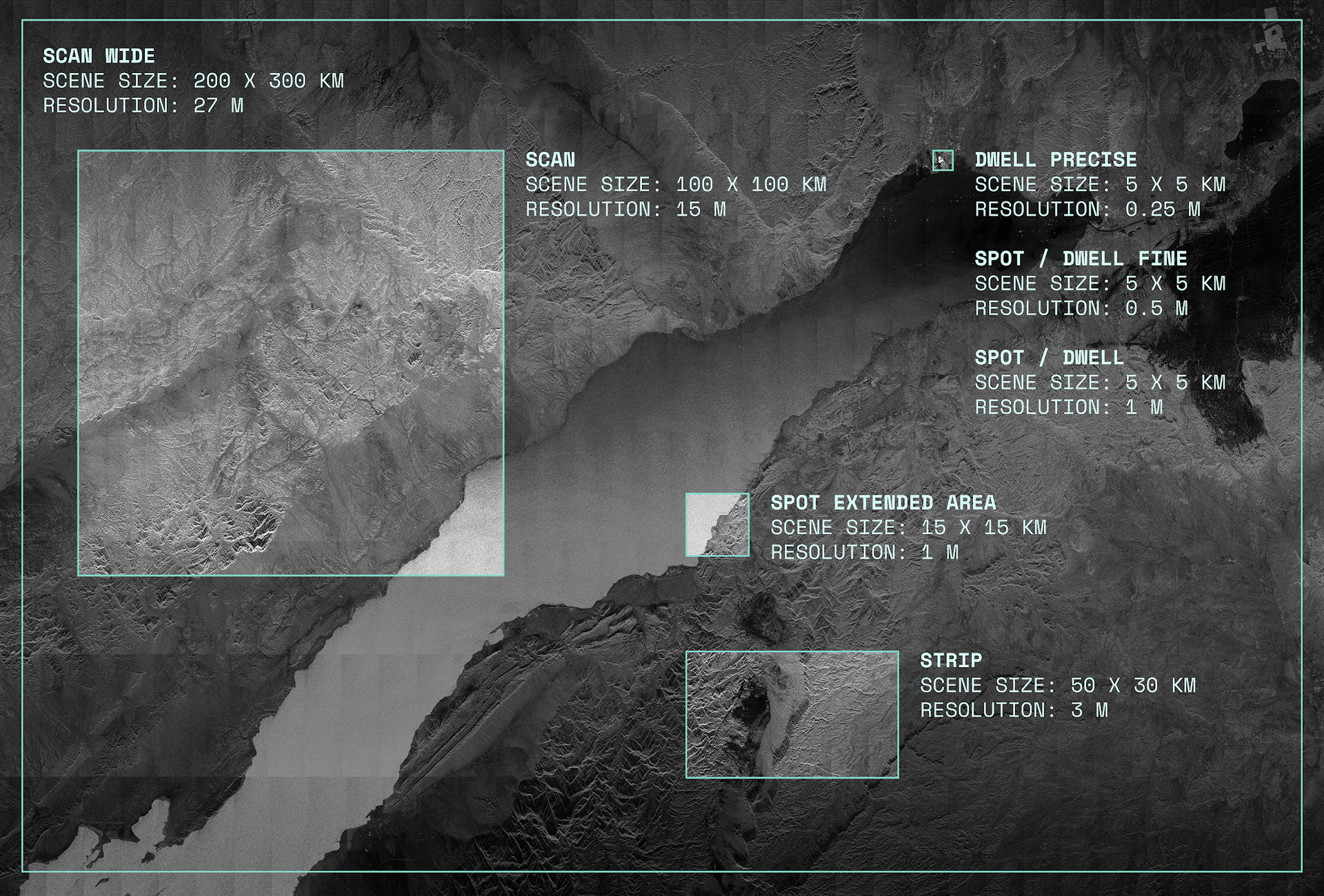
New imaging modes are being continuously developed, allowing for variations in resolution and the size of the captured areas. These range from the most precise Dwell Precise, providing 25 cm resolution over an area of 5 × 5 km, to Scan Wide, which delivers lower-resolution imagery but covers a swath 200 km wide / Photos: ICEYE
ICEYE is currently focusing its activities around three business areas. The first is the development and sale of complete solutions, including satellites, along with control and monitoring systems. The second is the sale of raw data, and the third is the sale of information derived from advanced imagery analysis. The company has developed such tools over the years for use in natural disaster monitoring, including floods, hurricanes, and large-scale fires.
Artificial intelligence is also increasingly being used for analysis. On July 14, the company launched a new tool called Flood Rapid Impact, which uses observational data to provide detailed information on floodwater extent. To determine the scale of flooding, satellite imagery is analyzed using machine learning.
This last area is also becoming highly significant for military applications. Rapid access to information and the interpretation of imagery are crucial during combat operations. In this field, ICEYE has partnered with leading companies, including SATIM, a specialist in automatic target identification systems, on February 10, 2025, and with Safran.AI on May 19. Work is also underway on the development and integration of radar satellite data into command systems. In March, an agreement was signed with Saab to cooperate in this area.
Without a doubt, having a company in Europe that was the first to build small SAR satellites successfully and, by all indications, currently possesses the best design of its class on the market, is a significant advantage for both our economic development and ensuring independence in the field of defense. An increasingly unpredictable international landscape means that Europe must strive for maximum independence from external suppliers, especially in such critical areas as reconnaissance. ICEYE now offers the ability to meet radar reconnaissance needs, and it is worth developing these capabilities so that European companies can maintain and strengthen their position among the world’s leaders.
